What is recorded here
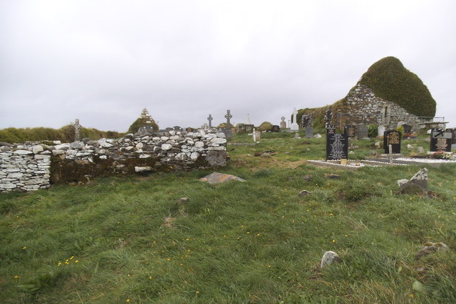
Grave Yard stands on a Cork ridge above the eastern sea, holding rows of unnamed stones and two chest tombs beside its church. People have laid dead there since the 1760s, while a pyramidal marker and six gabled tombs break the plain field in their own directions. The sea still passes below, and the yard still receives the occasional dead, keeping its quiet company with the coast.
On top of a ridge overlooking coastline to E, roughly rectangular graveyard enclosed by stone-faced earthen bank. Many rows of low, uninscribed headstones; two chest tombs to E of church (CO151-024002-); earliest inscriptions date to 1760s. Pyramidal grave marker in SW quadrant; six gabled tombs to W of church. Still in occasional use.
The above description is derived from the published 'Archaeological Inventory of County Cork. Volume 1: West Cork' (Dublin: Stationery Office, 1992). In certain instances the entries have been revised and updated in the light of recent research.
Date of upload/revision: 14 January 2009
A 19th-century graveyard associated with a church; significance as a local historic burial site with early inscriptions.
The monument record does not grant public access. Check the route and ask the landowner before entering private land.
- What survives
- Recorded monument
Places near here
 Myross ChurchRuins · 17 yd
 Cuaisín an GhainimhBay · 641 yd
 Faill a' TrahaneCliff · 965 yd
 Hut site in Reen (carbery West (e.d) By.)Hut site · 1143 yd
 Rón CarraigIslet · 1151 yd
 An Gróibin ThuaidhWood · 1206 yd
 Tráig MórBeach / strand · 1242 yd
 Trá na MuilleenBeach / strand · 1287 yd
 Cnoc Sheáin de BarraMountain / peak · 1316 yd
 Lios/RingfortArchaeological place · 1345 yd
 Low IslandIslet · 1475 yd
 Chapel in Low IslandChapel · 1505 yd
Other information
Photo: Mac McCarron · Creative Commons Attribution-ShareAlike 2.0