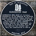
What is recorded here
This black commemorative plaque records: Gloucester Quay Gloucester owes much of its early prosperity to its location on the River Severn and received formal status as a port through a Royal Charter of 1580. The old quay was much frequented by sailing trows and barges working between Bristol and Shrewsbury, and continued to be used well into the 20th century. The present quay wall was constructed in 1887-8. Recorded plaque organisation: Port of Gloucester.
Gloucester Quay played a crucial role in Gloucester's economic development as a port city following its Royal Charter of 1580, facilitating trade via the River Severn until the 20th century.
A plaque record does not grant entry to a building or private land. View it from a public place unless permission is clearly given.
Places near here
 Outer Gatehouse, former Her Majesty's Prison GloucesterListed building · 124 yd
.jpg?width=1280) Old Customs HouseMemorial · 142 yd
Old Customs HouseMemorial · 142 yd Old Custom HouseListed building · 148 yd
 The Folk of GloucesterMuseum · 222 yd
 The Atlas BellMemorial · 236 yd
 Historic Gloucester DocksVisitor information · 237 yd
 WarehousesVisitor information · 257 yd
 Soldiers of GloucestershireMuseum · 314 yd
 BlackfriarsScheduled monument · 349 yd
 Coloured lights on ancient stoneAncient stone or rock art · 467 yd
 Lassington WoodWood · 1.8 mi
 Lassington HillMountain / peak · 2.0 mi
Other information
Photo: Ian S on Geograph · CC BY-SA 2.0