What is recorded here
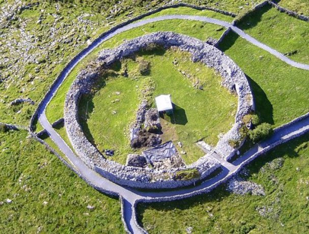
No visible entrance, no chamber, no hearth mark, no layer of lived life. The facts refuse the fairy label and the refusal is the shape: a small cashel on an east facing slope in Clare, mapped in 1842 and 1920, still standing with its outer wall almost complete. The region is crowded with cashels, which is why people invented a story for the one that would not explain itself.
On E-facing slope with views E–S, in rough pasture within a multiperiod field system (CL009-255----). Hachured on the 1842 and 1920 eds. of the OS 6-inch map. This small suboval cashel (int. dims. 17.6m N–S; 15.7m E–W; ext. dims. 22.1m N–S; 21.1m E–W) is defined by a wall (est. Wth c. 2m; int. H 0.2–0.6m; ext. H 0.4–0.8m), the outer face of which is visible almost all around. A later N–S drystone wall (Wth 0.6m; H c. 1m) is built over and may have damaged the E perimeter. An enclosure (CL009-030006-) lies c. 60m to SSE and 'Caherlisnanroum' (CL009-030005-) lies c. 104m to S.
Compiled by: Mary Tunney and Conn Herriott
Date of upload: 4 January 2022
The monument record does not grant public access. Check the route and ask the landowner before entering private land.
- What survives
- Recorded monument
Places near here
 CaherlisnanroumFairy fort / stone ringfort · 139 yd
 CaherconnellHeritage attraction · 458 yd
 Poulnabrone - Burren GeositeVisitor information · 536 yd
 Enclosure in PoulnabroneEnclosure · 644 yd
 Caherconnell Stone FortRuins · 646 yd
 The Portal TombVisitor information · 672 yd
 Poulnabrone DolmenHeritage attraction · 705 yd
 Cave of the Wild HorsesCave · 1182 yd
 Gleansleade Castle (in ruins)Castle, tower house · 1280 yd
 PoulnabroneMemorial · 1.2 mi
 Carran Church (in ruins)Church · 1.6 mi
 Site of Ballymurphy CastleCastle, tower house · 2.1 mi