Add the human story, a picture, a first-hand message or a missing place.
Earn 5 points after the picture is checked and accepted.
Add a pictureAdd its storyTalk or ask a questionAdd a new placeWhat is recorded here
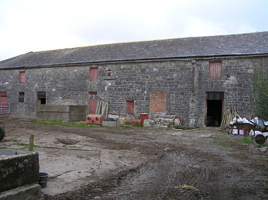
Farmyard complex, post-1840, including:(i) Detached eighteen-bay two-storey outbuilding on an L-shaped plan about a courtyard comprising eight-bay two-storey range with ten-bay two-storey perpendicular range. Hipped slate roofs on an L-shaped plan with clay ridge tiles, and cast-iron rainwater goods on cut-limestone eaves having iron brackets. Random squared rubble limestone walls with tooled cut-limestone quoins to corners. Square-headed window openings with no sills, tooled cut-limestone voussoirs, and louvered timber panel fittings having some tongue-and-groove timber panelled fittings. Square-headed door openings with tooled cut-limestone block-and-start surrounds having voussoirs, and timber boarded doors having overlights. Set back from road in grounds shared with Dunmore Park (House).(ii) Detached five-bay single-storey outbuilding about a courtyard with series of five elliptical-headed carriageways. Hipped slate roof with clay ridge tiles, and cast-iron rainwater goods on cut-limestone eaves having iron brackets. Random squared rubble limestone walls with tooled cut-limestone quoins to corners. Series of five elliptical-headed carriageways with tooled cut-limestone voussoirs, and no fittings.(iii) Freestanding cast-iron waterpump, c.1900, to courtyard comprising cylindrical base supporting fluted cylindrical shaft having spout (collecting into cut-limestone trough), curvilinear 'cow tail' handle, and fluted domed capping on moulded course.
This official record and map point do not grant access. Most recorded buildings are privately owned; view them only from public ground unless the owner allows entry.
Conversation about this place
Questions and messages sit beneath the source record. They are checked before appearing.
No questions or messages yet.
Ask a question or join the conversation