What is recorded here
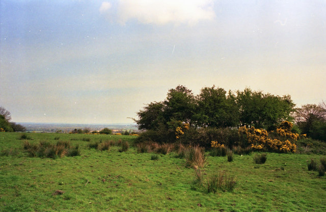
The rath in Coolaghflags is a 20-metre earthen mound on a north-facing ridge, its dished centre hidden beneath furze and hawthorn. It stands above wet boggy ground to the west and south, exposing a broad view across the Kilkenny landscape. People may have shaped that ridge into a boundary, watchpoint or dwelling long before the fairies entered the local name. The mound still holds its shape, while the story around it has blurred into legend.
On N-facing slope at the N end of a SW-NE ridge, in rough furzy pasture. The ground to the W and S of the monument is wet and boggy. There are extensive views to from NW-NE. The monument, known locally as ‘the rath’ is overgrown with furze bushes and hawthorn. A raised area (max. diam. 20m; ; diam. at top 15m; H 1.5m) with a slightly dished interior.
See attached:
KK030-003----_01 Sketch plan by Kieran Campbell
Compiled by: Jean Farrelly
Date of upload: 17 July 2023
The monument record does not grant public access. Check the route and ask the landowner before entering private land.
- What survives
- Recorded monument
Places near here
 Coolaghmore National SchoolMemorial · 1065 yd
 Catholic Church of Our Ladychurch/chapel · 1168 yd
 Holy well in CoolaghmoreHoly well · 1186 yd
 CastleCastle, tower house · 1202 yd
 Coolaghflags Catholic Chapelchurch/chapel · 1211 yd
 HawthornHawthorn · 1224 yd
 James (Jim) McKennaMemorial · 1751 yd
 Garryrickin Ringfort (rath)Archaeological place · 1.1 mi
 European ashEuropean ash · 1.2 mi
 Bawn in GarryrickinBawn · 1.7 mi
 KillameryVisitor information · 2.5 mi
 Killamery High CrossVisitor information · 2.6 mi
Other information
Photo: Kieran Campbell · CC BY-SA 2.0