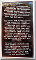
What is recorded here
This bronze commemorative plaque records: This plaque celebrates the completion by Cardiff Council of the creation of a pedestrian friendly environment in High Street and St Mary Street and recognises the efforts of those who physically carried out the works. High Street and St Mary Street saw substandial change between 1600 and 1800 and were the main streets connected by Quay Street and The Golate to the river with ships coming in from all over the world. In 1850 the river Taff was straightened to facilitate the cosntruction of the General Railway station and the docks area of Cardiff was developed. For over five hundred years these streets have been the main north / south transport route through the city and have now been handed over to the people of Cardiff and visitors to the city for their use and enjoyment. Recorded plaque organisation: Cardiff Council.
This plaque commemorates Cardiff Council's transformation of High Street and St Mary Street into a pedestrian-friendly environment, honoring the workers who executed the changes; these streets have historically served as central transport routes and hubs for international trade since the 1600s.
A plaque record does not grant entry to a building or private land. View it from a public place unless permission is clearly given.
Places near here
 CardiffCity · 28 yd
_building_-_Hodge_House,_Cardiff_-_geograph.org.uk_-_8209207.jpg?width=1280) Hodge HouseOffice · 61 yd
Hodge HouseOffice · 61 yd The City Arms; 10-12 Quay Street, Cardiff; The Dovers Arms; Cattle Market, CardiffMeat Market; Public House · 82 yd
 Jones' Court, CardiffRecorded historic place · 99 yd
 Cardiff Castle and groundsCastle, fort or tower · 162 yd
 Cardiff Castle Walls and Clock TowerCastle, fort or tower · 197 yd
 Gareth BaleMemorial · 213 yd
 Cardiff, The Hayes Island Snack BarIsland · 283 yd
 Cardiff CastleCastle · 360 yd
 Millennium Milepost Cardiff StadiumVisitor information · 500 yd
 Utilita Arena CardiffHeritage attraction · 623 yd
 Memorial to Welsh Volunteers in the Spanish Civil WarMemorial · 768 yd
Other information
Photo: Jaggery on Geograph · CC BY-SA 2.0