What is recorded here
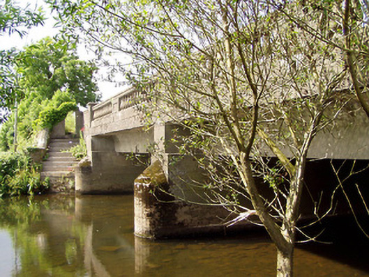
On River Aherlow which flows W to E. This is a five span bridge, each span is of equal height, with semi-circular arches (N span Wth 4.2m). The road rises across the bridge (L 33.7m; Wth 6.95m between parapets), which is fairly level. There is a parapet on either side (E Wth 0.44m; H 0.9m; W Wth 0.46m; H 0.78m). The upstream, W face has four cut-stone cutwaters and each arch has cut-stone voussoirs with a pronounced keystone. The E face is heavily overgrown with ivy. The arches have roughly cut voussoirs. The original bridge (Wth 4.5m) has been widened. This is clearly visible where the later arches of the extension (Wth 3.35m) to the W are built up against the earlier bridge. The lower courses were keyed into the existing masonry. The bridge extension has clear evidence of plank-centring under the arch which is not visible on the earlier arches. The extension appears to be of mid-late 18th-century date which implies that the original bridge is 17th or early 18th-century in date.
Compiled by: Jean Farrelly
Date of upload: 26 August 2011
The monument record does not grant public access. Check the route and ask the landowner before entering private land.
- What survives
- Recorded monument
Places near here
 Cappa Old Bridgebridge · 1 yd
 Cappa New Bridgebridge · 1020 yd
 Enclosure in Ballymorris (killardry Par.)Enclosure · 1137 yd
 Enclosure in ToureenEnclosure · 1479 yd
 Cashlaunbeg (in ruins)Bawn · 1542 yd
 Cappa Castle (in ruins)Castle, tower house · 1588 yd
 Caucasian zelkovaCaucasian zelkova · 1594 yd
 Cappa WoodWood · 1620 yd
 Slieveanard NE TopMountain / peak · 2.0 mi
 SlieveanardMountain / peak · 2.2 mi
 Caher AbbeyHeritage attraction · 4.3 mi
 Siege of Cahir Castlesiege · 4.4 mi