Add the human story, a picture, a first-hand message or a missing place.
Earn 5 points after the picture is checked and accepted.
Add a pictureAdd its storyTalk or ask a questionAdd a new placeWhat is recorded here
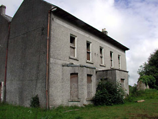
Detached five-bay two-storey double-pile house, c.1850, possibly over basement on a symmetrical plan incorporating fabric of earlier house, c.1700, with single-bay single-storey flat-roofed projecting porch to centre having single-bay single-storey flanking canted bay windows. Burnt, c.1920. Extensively renovated, post-1925. Now disused and derelict. Gable-ended double-pile (M-profile) roof with slate. Clay ridge tiles. Rendered chimney stacks. Overhanging timber eaves with paired consoles. Cast-iron rainwater goods. Flat-roofed to porch and to canted bay windows. Materials not visible. Roughcast walls. Unpainted. Rendered dressings including bands to first floor and to eaves. Square-headed openings (including to canted bay windows). Stone sills. Replacement 1/1 timber sash windows, c.1925 (now missing glazing). Square-headed door opening to porch. Moulded rendered surround. Replacement timber panelled door, c.1925. Set back from road in own grounds. Overgrown grounds to site. Detached three-bay double-height outbuilding, c.1850, to north-west with square-headed integral carriageway. Now disused. Hipped and gable-ended roof with slate. Clay ridge tiles. Remains of cast-iron rainwater goods. Roughcast walls (probably over rubble stone construction). Painted. Square-headed window openings. No sills. Remains of timber fittings. Square-headed integral carriageway. Fittings now gone. Remains of rubble stone walled garden, c.1850, to north with round-headed pedestrian gateway having wrought iron gate.
This official record and map point do not grant access. Most recorded buildings are privately owned; view them only from public ground unless the owner allows entry.
Conversation about this place
Questions and messages sit beneath the source record. They are checked before appearing.
No questions or messages yet.
Ask a question or join the conversation