What is recorded here
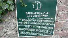
This green commemorative plaque records: GRISLEYMIRES LANE (also Grisley Myres). The name is derived from an Old English word 'gris' for swine and 'mire' meaning muddy place. Until c1920 piggeries belonging to the Royal Oak Inn were situated near here and until c1960 there was a pond and stream, now culverted, close to the present entrance to Park House Coachworks. The lane which now leads just to Park Road originally had a western extension providing access to common pasture on Milnthorpe Marsh at Fishcarling Head. Close to Dallam Chase was a pinfold for stray stock which was provided with its own water pump. Later the site became wasteland known as 'Grisley Tip'. Recorded plaque organisation: Parish of Milnthorpe.
The Pinfold in Milnthorpe served as a pen for impounding stray livestock, reflecting medieval local governance practices; it was later abandoned and the area became known as 'Grisley Tip'.
A plaque record does not grant entry to a building or private land. View it from a public place unless permission is clearly given.
Places near here
 Cross Keys HotelListed building · 325 yd
 Market CrossListed building · 335 yd
 St Anthony's TowerMonument · 487 yd
 Milestone north of MilnthorpeMonument or public art · 657 yd
 Milnthorpe HillMountain / peak · 930 yd
 Park HillMountain / peak · 1076 yd
 Fishcarling HeadHeadland · 1639 yd
 Heron Corn MillMuseum · 1.1 mi
 Heversham HeadVisitor information · 1.3 mi
 Haverbrack Bank Slip CaveCave or cavern · 1.3 mi
 Longtail WoodWood · 1.4 mi
 Heversham Head PlantationForest · 1.4 mi
Other information
Photo: flipflopnick · CC BY 2.0