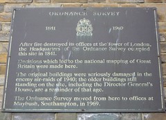
What is recorded here
This bronze commemorative plaque records: Ordnance Survey 1841 - 1969 After fire destroyed its offices at the Tower of London, the Headquarters of the Ordnance Survey occupied this site in 1841. Decisions which led to the national mapping of Great Britain were made here. The original buildings were seriously damaged in the enemy air-raids of 1940; the older buildings still standing on the site, including the Director General's House, are a reminder of that age. The Ordnance Survey moved from here to offices at Maybush, Southampton, in 1969.
The Ordnance Survey is a government agency responsible for the national mapping of Great Britain, established in 1791; its headquarters relocated multiple times due to significant events such as fires and bombings, reflecting its enduring role in cartography and geographic information.
A plaque record does not grant entry to a building or private land. View it from a public place unless permission is clearly given.
Places near here
 Ordnance Survey MonumentMonument or public art · 134 yd
 Titanic Engineers MemorialMemorial · 235 yd
 5, Grosvenor SquareListed building · 238 yd
 MosaicMemorial · 296 yd
 Statue in East ParkMonument or public art · 296 yd
 Drinking FountainListed building · 302 yd
 Statue of Sir Isaac WattsMonument or public art · 358 yd
 Milestone on The AvenueMonument or public art · 481 yd
 Bargate StreetVisitor information · 1148 yd
 Entrance cavernCave or cavern · 1242 yd
 Castle wallScheduled monument · 1287 yd
 Castle Gateway, Castle LaneScheduled monument · 1303 yd
Other information
Photo: John Levin · CC BY-SA 2.0