What is recorded here
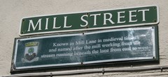
This green commemorative plaque records: Known as Mill Lane in medieval times and named after the mill working from the stream running beneath the lane from east to west
Mill Street was formerly known as Mill Lane during medieval times, named for a mill that operated along a stream flowing underneath the lane. The existence of this mill highlights the area's historical reliance on water power for industrial activities, indicative of medieval and early modern economic practices.
A plaque record does not grant entry to a building or private land. View it from a public place unless permission is clearly given.
Places near here
 55, High StreetListed building · 28 yd
 City Arms InnListed building · 63 yd
 Luellin's monumentMonument or public art · 175 yd
 Browne's GateScheduled monument · 252 yd
 Sculpture commemorating the 800th anniversary of the Bishop's Palace, WellsPublic sculpture · 350 yd
 The Bishop's PalaceCastle · 431 yd
 Waterfall at The Bishop's Palace - WellsWaterfall · 502 yd
 Tor Hill, WellsMountain or hill · 948 yd
 Wells CemeteryChurch, cross or graveyard · 1342 yd
 Stoberry WarrenForest · 1604 yd
 Dulcote GrottoCave or cavern · 1.2 mi
 Hay HillMountain / peak · 1.5 mi
Other information
Photo: gnomonic · CC BY 2.0