What is recorded here
Standing on the N bank of the Camoge River 650m NW of Monasteranenagh Cistercian Abbey (LI031-050004-). Two eel-weirs (LI031-125001/002-) are located 70m to SW and 45m to S respectively. Depicted as a rectangular structure on the 1840 ed. OSi 6-inch map where it is annotated ‘Mill (in Ruins)’. Annotated ‘Creamery’ on the 1897 ed. OSi 25-inch map. According to Westropp (1889, 238) this mill may have stood on the site of the original medieval Abbey Mill. The 1654-56 Civil Survey of Limerick recorded that Lady Anne Southwell was the owner in Monasteranenagh of, ‘half a plow[lan]d w[i]th a mill seate and an Eele weare [LI035-125002-]’ (Simington 1938, 371).
The watermill depicted standing parallel to the Camoge River on the 1840 ed. OSi 6-inch map was converted into a creamery in the second half of the 19th century. The creamery was surveyed by the ASI in 2007 and described as a detached seven-bay four-storey structure constructed of roughly dressed limestone with dressed quoins. Extensions have been added to the north and south. The square headed openings at 4th floor level are blocked-up while elsewhere some have red brick voussoirs and limestone sills. The building has a pitched corrugated-iron roof. The mill race has been filled-in and the mill wheel removed to Croom village. Creamery described by the National Inventory of Architectural Heritage (NIAH) as a; ‘Detached seven-bay four-storey creamery, built c. 1880, with recent extensions to front (north) elevation, rear (south) elevation and abutting shed to west elevation. Pitched corrugated-iron roof. Roughly-dressed limestone walls with dressed quoins’ (www.buildingsofireland.ie; NIAH Reg. No. 21903103).
Monitoring was undertaken by Rose Cleary under licence no. 02E1460 (Cleary 2002) the results of which were summarised as follows; ‘A proposed house development adjacent to a mill and mill-race required monitoring during the groundworks stage. The site is on the north-east side of the zone of archaeological potential surrounding the mill and mill-race. No archaeological features or finds were uncovered’ (Cleary 2004, 339). The mill building is now occupied by a creamery visible on OSi orthophoto taken between 2005-12 and on Google Earth orthoimage dated 14/02/2020.
Compiled by: Martin Fitzpatrick
Date of upload: 1 April 2021
The monument record does not grant public access. Check the route and ask the landowner before entering private land.
- What survives
- Recorded monument
Places near here
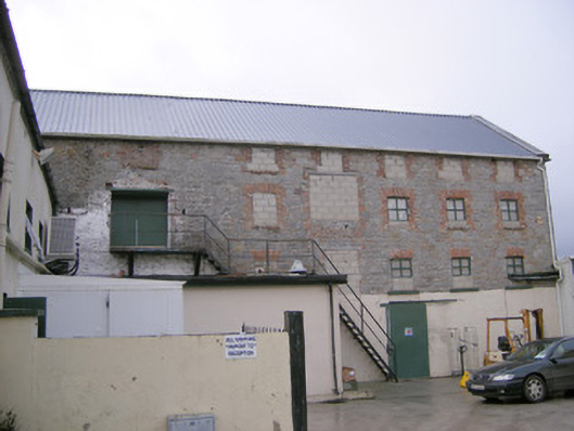 mill (water)mill (water) · 8 yd
 RIC barracksRIC barracks · 113 yd
 Burial GroundChildren's burial ground · 550 yd
 Sheenafinnoge Fort, hachuredBarrow, bowl-barrow · 672 yd
 Monasteranenagh AbbeyHeritage attraction · 736 yd
 Bawn in Rathmore NorthBawn · 1.3 mi
 Bawn in TullovinBawn · 1.6 mi
 European ashEuropean ash · 1.7 mi
 Biodiversity in the Maigue CatchmentVisitor information · 2.0 mi
 Dysert AenghusaHeritage attraction · 3.1 mi
 Villiers WellSpring · 3.6 mi
 Kinnoor WellSpring · 4.8 mi