What is recorded here
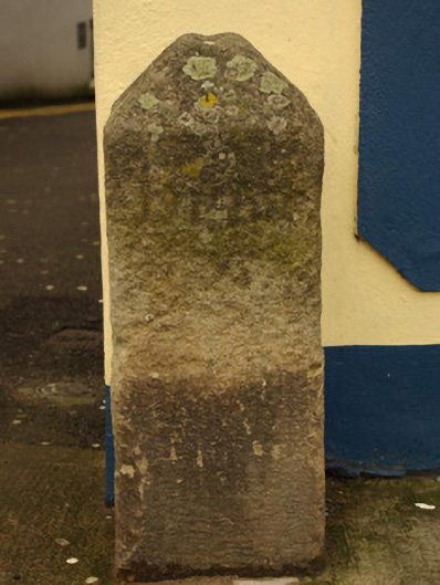
Freestanding granite milestone on rectangular-plan, erected c. 1780, having pyramidal head. Inscriptions to the east and west faces now illegible. Located adjacent to corner of building on footpath at the junction of Upper Main Street and Church Street, and to the east of Donegal Town centre.
This milestone makes an attractive, if subtle, historical impression in the streetscape to the east of Donegal Town centre. Unfortunately the inscriptions are now illegible but the distance would have been in ‘Irish Miles’, which are longer than the standard mile measurement used today. It probably dates to the late eighteenth-century or to the first decades of the nineteenth century, a period when the Grand Juries were responsible for a great deal of improvement in the road transport network throughout Ireland, particularly the development of a series of ‘turnpike roads’ (from 1729) on which milestones are usually found. Milestones appears to be marked along this road on the Taylor and Skinner road maps of 1777 – 1783, although there were no turnpike roads in Donegal before 1805. This simple item of street furniture acts as a subtle historical reminder the great coach travel in Ireland, and is an integral element of the built heritage of the local area. It may have been moved from a site very close to its present location in recent years.
This does not grant access. Most recorded buildings are privately owned; view them only from public ground unless the owner allows entry.
Places near here
 post boxpost box · 13 yd
 Catholic Church of the Four Masterschurch/chapel · 95 yd
 Four Masters MemorialMemorial · 242 yd
 DONEGALHistoric town · 253 yd
 Donegal CastleMuseum · 275 yd
 Donegal Railway Heritage CentreMuseum · 350 yd
 Horse-chestnutHorse-chestnut · 454 yd
 Donegal Friary GraveyardGraveyard · 714 yd
 Revlin Enclosure near Donegal AbbeyEnclosure · 775 yd
 Siege of Donegalsiege · 867 yd
 Wych ElmWych Elm · 1.3 mi
 Ballyboyle IslandIslet · 1.7 mi
Other information
Photo: National Inventory of Architectural Heritage · Website use allowed for educational or private purposes with source credit