What is recorded here
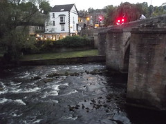
This bronze commemorative plaque records: Matlock Bridge This downstream side of the bridge dates from the 1400s. The bridge was widened in 1904 - look under the arches to see that this is bridge of two halves. This viewpoint was planned by Matlock Civic Association in 2005 Recorded plaque organisation: Matlock Civic Association.
Matlock Bridge, with its downstream side dating from the 1400s, is a historical structure that has been widened and modified over time, reflecting the town's development and engineering evolution; it serves as a key crossing point over the Derwent River.
A plaque record does not grant entry to a building or private land. View it from a public place unless permission is clearly given.
Places near here
 Matlock BridgeScheduled monument · 16 yd
 Matlock Bridge (over River Derwent)Listed building · 23 yd
 Former Station Masters House at Matlock StationListed building · 139 yd
 Hall Leys Park RailwayHeritage attraction · 319 yd
 Matlock Town F.C.Football ground · 321 yd
 War MemorialMemorial · 437 yd
 Batchelor's OakOak · 471 yd
 Dene FieldsWood · 480 yd
 Old Milestone by the A6, High Tor HotelMonument or public art · 1113 yd
 Roman 'Cave', High TorCave or cavern · 1284 yd
 Bailey's TumpBattlefield · 1355 yd
 Waterfall on Bentley Brook, LumsdaleWaterfall · 1716 yd
Other information
Photo: Elliott Brown · CC BY-SA 2.0