
What is recorded here
Map note: Kerrera, Mount Pleasant appears on the map as a barrow near Oban, Argyll and Bute, Scotland. See what else is recorded around this spot before making up the rest.
Places near here
Photo credits
- Peter McDermott, Wikimedia Commons · CC BY-SA 2.0
- Euan Nelson, Wikimedia Commons · CC BY-SA 2.0
- David Dixon, Wikimedia Commons · CC BY-SA 2.0
- James Denham, Wikimedia Commons · CC BY-SA 2.0
- Walter Baxter, Wikimedia Commons · CC BY-SA 2.0
- Peter Jeffery, Wikimedia Commons · CC BY-SA 2.0
- David P Howard, Wikimedia Commons · CC BY-SA 2.0
- John Baker, Wikimedia Commons · CC BY-SA 2.0
- Maker not stated on source page, www.dailyrecord.co.uk
 Mount PleasantNo Class (event) · 80 yd
 Kerrera, ArdantriveFarmhouse (post Medieval), Farmstead (post Medieval) · 296 yd
 Ardantrive BayBay · 459 yd
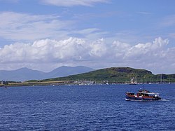 KerreraFindspot (20th Century), Barbed and Tanged Arrowhead (flint)(prehistoric) · 554 yd
 Oban, Town CentreGeneral View (19th Century) - (20th Century) · 855 yd
 Viscount Kingarth: Oban Bay, Firth of LornSchooner (19th Century) · 957 yd
 Oban, Gallanach Road, Dungallan Parks, Public ConveniencesToilet (20th Century) (1933) · 1050 yd
 Oban, Gallanach Road, Boat HouseBoathouse (20th Century) · 1073 yd
 Oban BayBay · 1110 yd
 Oban, Gallanach Road, the Manor HouseBank (financial) (19th Century) (1826)-(1830), Country House (18th Century) · 1193 yd
 Pulpit HillMountain / peak · 1360 yd
 Oban War & Peace MuseumMuseum · 1691 yd
More archaeology and monuments in Argyll and Bute · All of Argyll and Bute

What do you know about this place?Tap to add a comment or ask a question