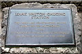
What is recorded here
This bronze commemorative plaque records: Izaak Walton Gauging Station This weir was constructed by the Trent River Authority in 1969. It's purpose is to measure continually the flow of water in the river. Recorded plaque organisation: Trent River Authority.
The Izaak Walton Gauging Station, built in 1969 by the Trent River Authority, serves a critical role in monitoring the water flow of the River Trent, aiding in flood management and water resource planning.
A plaque record does not grant entry to a building or private land. View it from a public place unless permission is clearly given.
Places near here
 DovedaleHeritage attraction · 50 yd
 Dovedale CastleHeritage attraction · 498 yd
 Thorpe CloudMountain / peak · 545 yd
 Lover's LeapViewpoint · 876 yd
 Bunster HillMountain / peak · 879 yd
 St Bertram's Well north of IlamOld or holy well · 1156 yd
 Bridge Over River ManifoldListed building · 1249 yd
 Mary Watts-Russell Monument - IlamMonument or public art · 1254 yd
 Mrs Watts-russell MemorialListed building · 1274 yd
 The slope of Bunster HillMountain or hill · 1402 yd
 Reynard's Cave, Dove DaleCave or cavern · 1610 yd
 Reynard's Cave, DovedaleCave or cavern · 1626 yd
Other information
Photo: Mat Fascione on Geograph · CC BY-SA 2.0