What is recorded here
Indicated is a ruined fairy fort on a sloping Mayo hillock where a hidden cave still breathes beneath hazel and hawthorn. Cattle may walk across its shallowed bank, but the land keeps its shape: a round chamber slightly larger than life, tilted toward the sky. What was built there has been forgotten, reduced to pasture and rumour, yet the cave remains named and known. Forgetting does not erase; it only stops asking.
In pasture, located at the NNE end of a hillock/drumlin which slopes down to the WNW, NNE and steeply to the ESE.
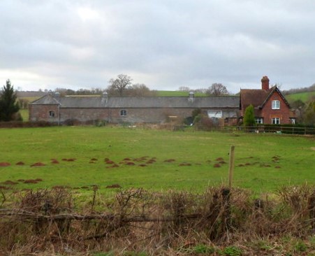
This rath is depicted on the 1838 OS 6-inch map as a circular embanked enclosure (diam. c. 35m), with a Man-made underground passage marked as ‘Cave’ in the NE quadrant; it is not shown on later map editions. The enclosing bank was partly levelled in the past. The remains consist of a roughly circular raised area (34m NNE-SSW) defined by a broadly sloping scarp (H 1.5m at N; 2m at W) which is entirely levelled for a short section at S. A Man-made underground passage (MA070-131002-) is located in a copse of hazel and hawthorn in the SE quadrant. (Pers. comm. Richard Crumlish).
Attached images are provided courtesy of Richard Crumlish:
MA070-131001-_01.JPG Rath viewed from NNE
Compiled by: Jane O’Shaughnessy
Date of upload: 13 August 2021
The monument record does not grant public access. Check the route and ask the landowner before entering private land.
- What survives
- Recorded monument
Places near here
 bridgebridge · 721 yd
 Greenvillefarm house · 796 yd
 River WoodWood · 1354 yd
 TowerRound tower · 1446 yd
 CastleCastle, unclassified · 1487 yd
 Holy WellHoly well · 1512 yd
 Sunken GardenWood · 1598 yd
 National Museum of Ireland, Country LifeMuseum · 1613 yd
 Moyhenna Castle in ruinsCastle, unclassified · 2.2 mi
 Battle of CastlebarMajor battlefield · 3.5 mi
 Saint John Baptist de La SalleMemorial · 3.7 mi
 1798 MemorialMemorial · 3.8 mi
Other information
Photo: Credit not shown in the picture search · Rights wording not checked; contact us if this picture should be removed