What is recorded here
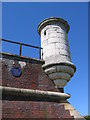
This blue commemorative plaque records: This 17th century "watchtower" marks the east point of Hull Citadel. Built 1681-90, the citadel was a massive triangular fort incorporating earlier defences alongside the river Hull. It was levelled in 1863-4 Recorded plaque organisation: Hull Civic Society.
Hull Citadel was a significant defensive structure built between 1681-90 to protect the city of Hull; it featured a notable "watchtower" and served as a crucial fortification until its demolition in 1863-64.
A plaque record does not grant entry to a building or private land. View it from a public place unless permission is clearly given.
Places near here
 George V postbox on Hedon Road, HullOld post box · 397 yd
 Former Trinity House Buoy ShedListed building · 465 yd
 A promenade sculpture on Victoria Dock, HullPublic sculpture · 481 yd
 Statue of William Wilberforce, HullMonument or public art · 571 yd
 Siege of Hullsiege · 724 yd
 Wilberforce Monument, HullMonument or public art · 870 yd
 Land of Green GingerMemorial · 878 yd
 Victoria Pier Information SignVisitor information · 966 yd
 Seamen's memorialMemorial · 1018 yd
 Beverley GateArchaeological place · 1130 yd
 Millennium Milepost HullVisitor information · 1258 yd
 Lister CourtListed building · 549 yd
Other information
Photo: Stephen Horncastle on Geograph · CC BY-SA 2.0