Overview
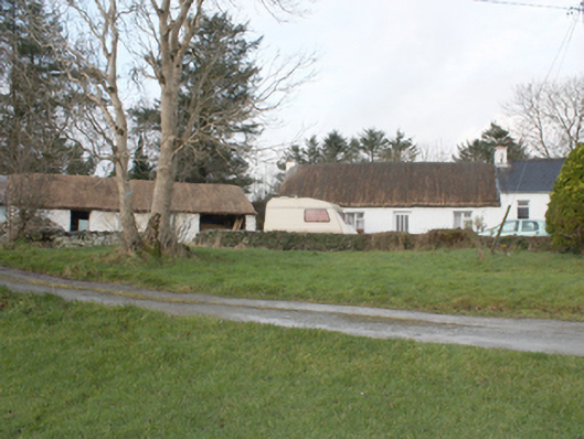
house — TULLYNAVINN is recorded as house in Donegal. Detached four-bay single-storey vernacular house, built c. 1800, with two-bay single-storey slated extension to north gable. Pitched thatched roof, smooth rendered gable ended chimneystacks with rendered coping
Why it was built
The saved account records: Detached four-bay single-storey vernacular house, built c. 1800, with two-bay single-storey slated extension to north gable.
People and work
The saved account records: Pitched thatched roof, smooth rendered gable ended chimneystacks with rendered coping
How it changed
The saved account records: cast-iron rainwater goods to extension.
What survives
The saved account records: Set at side of laneway with multiple-bay single-storey outbuildings to south with pitched thatch and corrugated-metal roofs, roughcast rendered and whitewashed walls, and square-headed openings with matchboard timber doors.
Why it mattered
house — TULLYNAVINN matters for the exact reasons given in its official assessment, rather than merely because it is an old structure. The source records: Despite the loss of original fenestration, this is a good vernacular thatched house, significantly enhanced by the retention of its thatched outbuildings. Thatched buildings, although still relatively common in Inishowen, nationally are becoming increasingly rare, making their survival a matter of importance. The rounded pitched roof is designed to minimise the impact of high winds, demonstrating the subtle adaptation of more common thatch detail to accommodate local climatic variations in exposed areas such as the Inishowen peninsula. The house is shown on the Ordnance Survey first edition six-inch map of c.… This explains what the place adds to local life, the street or the surviving built history.
History checked 15 August 2026 against the named sources below.
Add the human story, a picture, a first-hand message or a missing place.
Earn 5 points after the picture is checked and accepted.
Add a pictureAdd its storyTalk or ask a questionAdd a new placeThis official record and map point do not grant access. Most recorded buildings are privately owned; view them only from public ground unless the owner allows entry.
Conversation about this place
Questions and messages sit beneath the source record. They are checked before appearing.
No questions or messages yet.
Ask a question or join the conversation