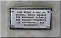
What is recorded here
This commemorative plaque records: This stone is one of several which marked the boundary between Heptonstall and Wadsworth
This stone marks the historical boundary between the townships of Heptonstall and Wadsworth, reflecting medieval land divisions that shaped local governance and community identity.
A plaque record does not grant entry to a building or private land. View it from a public place unless permission is clearly given.
Places near here
 Township boundary stoneMonument or public art · 1 yd
 Battle of Heptonstallbattle · 70 yd
 The old bridge over the Hebden Water at Hebden BridgeScheduled monument · 72 yd
 The Old Bridge Over the Hebden WaterListed building · 72 yd
 West End Bridge over the Hebden WaterListed building · 99 yd
 Knife sundial sculpture in St George's SquarePublic sculpture · 118 yd
 The Rochdale CanalVisitor information · 172 yd
 Common Bank WoodWood · 361 yd
_in_Joan_Wood,_Hebden_bridge_-_geograph.org.uk_-_4465848.jpg?width=1280) Joan WoodWood · 682 yd
Joan WoodWood · 682 yd Heptonstall MuseumMuseum · 1059 yd
 Horsehold ScoutCliff · 1100 yd
 Cock HillMountain / peak · 1.1 mi
Other information
Photo: Humphrey Bolton on Geograph · CC BY-SA 2.0