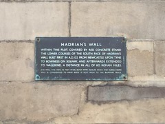
What is recorded here
This bronze commemorative plaque records: Hadrian's Wall. Within this plot, covered by red concrete stand the lower courses of the south face of Hadrian's wall built first in A.D. 122 from Newcastle Upon Tyne to Bowness on Solway, and afterwards extended to Wallsend, a distance in all of 80 Roman miles. The wall was here 10 feet wide, built with ashlar faces and rubble core and is considered to have been 15 feet high to the rampart walk.
Hadrian's Wall was constructed under Emperor Hadrian beginning in A.D. 122 as a defensive fortification marking the northern limit of Roman Britain, stretching about 80 Roman miles from coast to coast. The wall exemplifies Roman military architecture and served to control movement and taxation across its length.
A plaque record does not grant entry to a building or private land. View it from a public place unless permission is clearly given.
Places near here
 Irving HouseListed building · 7 yd
 Mining InstituteMuseum · 57 yd
 Neville Hall and Wood Memorial HallListed building · 61 yd
 Stephenson MonumentVisitor information · 85 yd
 George Stephenson monumentMonument or public art · 110 yd
 Statue of Queen VictoriaMonument or public art · 150 yd
 St Nicholas StreetVisitor information · 157 yd
.jpg?width=1280) Rutherford Memorial FountainMemorial · 269 yd
Rutherford Memorial FountainMemorial · 269 yd The Town WallMemorial · 271 yd
 Milepost NewcastleMonument or public art · 340 yd
 Wreck of wooden boat in River Tyne mudShipwreck · 542 yd
 Lloyds BankListed building · 68 yd
Other information
Photo: Simon Harriyott · CC BY 2.0