What is recorded here
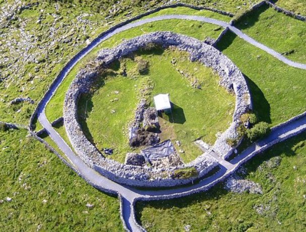
Fairy fort in Poulanine, County Clare: a large stone ringfort on a high plateau, with a narrow north-west entrance and a later wall climbing part of its outer edge. People may have lived, herded or hidden there before the stones softened into grass and legend. The fairies took the rest, leaving only the shape of a room large enough to remember.
At a high point on a plateau with land sloping most steeply to E, in rough pasture on karst pavement under thin grass cover. Within a multiperiod field system (CL009-255----). Hachured on the 1842 and 1920 eds. of the OS 6-inch map. This large subcircular cashel (int. dims. 49m N–S; 46.9m E–W; ext. dims. 55.2m E–W; 54.9m N–S) is defined by a low, grass-covered, double-faced wall (Wth 1.9–3.3m; int. H 0.4–0.8m; ext. H 0.7–0.8m). Westropp (1917, 74) noted that this wall was built of very coarse thin slabs, and had been reduced to its footings. The interior is slightly concave. The cashel entrance (int. Wth 1m; ext. Wth 1.2m) is at NW and comprises a passage lined on each side by two large stones. An upright stone (H 1.1m; L 0.4m; Wth 0.15m) stands at the S side of the entrance exterior. There is a small subrectangular hut site (CL009-030020-) W of centre. A later drystone wall (Wth 0.8m; H 1.2) is built over the outer wall-face from NW to S.
A cairn (CL009-030015-) lies c. 20m to the ESE, an enclosure (CL009-030002-) lies c. 58m to the SSW and a cashel (CL009-030004-) lies c. 160m to the SE.
Compiled by: Mary Tunney and Conn Herriott
Date of upload: 4 January 2022
The monument record does not grant public access. Check the route and ask the landowner before entering private land.
- What survives
- Recorded monument
Places near here
 CaherlisnanroumFairy fort / stone ringfort · 312 yd
 CaherconnellHeritage attraction · 663 yd
 Poulnabrone - Burren GeositeVisitor information · 665 yd
 Font in KilcorneyFont · 723 yd
 The Portal TombVisitor information · 781 yd
 Poulnabrone DolmenHeritage attraction · 797 yd
 Caherconnell Stone FortRuins · 858 yd
 Cave of the Wild HorsesCave · 1087 yd
 Gleansleade Castle (in ruins)Castle, tower house · 1179 yd
 PoulnabroneMemorial · 1.3 mi
 Carran Church (in ruins)Church · 1.7 mi
 Site of Ballymurphy CastleCastle, tower house · 2.1 mi