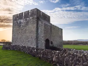
What is recorded here
On a generally level area, in improved rough pasture. The field surface is very uneven across this area due to rock outcrop. Identified on a satellite image as a subcircular enclosure associated with a field system (CL035-160001-) (https://binged.it/2mXvaZJ, accessed 6 March 2017). A subcircular area (23m N-S; 22m E-W) defined by the remains of a sod covered wall (int. H 0.6m; ext. H 0.25m; Wth at top 1.5m; overall Wth 4.8m) with the stones protruding from the surface in places. The interior takes the form of a gentle depression and has a lumpy surface due to presence of loose rocks and potential rock outcrop covered by sod. A number of linear field walls representing a field system (CL035-160001-) radiate from the exterior of the enclosure at NE, S, W and NW.
The following images have been uploaded:
CL035-160----_02.jpg From SW. General view of monument.
CL035-160----_01.jpg From ESE. Cross-sectional view of bank at NNE.
Compiled by: Mary Tunney, Alison McQueen and Vera Rahilly
Date of upload: 10 July 2018
The monument record does not grant public access. Check the route and ask the landowner before entering private land.
- What survives
- Recorded monument
Places near here
 Enclosure in LissofinEnclosure · 344 yd
 Children's Burial GroundArchaeological place · 416 yd
 worker's houseworker's house · 582 yd
 Lissofin Castle (in ruins)Castle, unclassified · 654 yd
 Bunavory Castle (in ruins)Castle, unclassified · 1755 yd
 The StablesGallery · 1.0 mi
 Saint Mochulla's Church (Tulla)graveyard/cemetery · 1.1 mi
 Cloghleagh RockNamed rock · 1.9 mi
 The RingfortHeritage attraction · 3.2 mi
 Derrymore WoodWood · 4.9 mi
 HawthornHawthorn · 7.5 mi
 G.A.A. Commemorative StoneMemorial · 8.3 mi
Other information
Photo: Credit not shown in the picture search · Rights wording not checked; contact us if this picture should be removed