What is recorded here
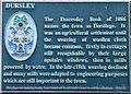
This black commemorative plaque records: Dursley. The Domesday Book of 1086 names the town of Dersilege It was an agricultural settlement until the weaving of woollen cloth became common, firstly in cottages still recognisable by their large upstairs windows, when in mills powered by water. In the late c18th weaving declined and many mills were adapted to engineering purposes which are still important to the town. This place was funded by Dursley Town Council and Stroud District Council to make the millennium 2000AD. Recorded plaque organisation: Stroud District Council, Dursley Town Council.
Dursley, named Dersilege in the Domesday Book of 1086, transitioned from an agricultural settlement to a center for woollen cloth weaving before adapting to engineering industries in the late 18th century, which remain significant today.
A plaque record does not grant entry to a building or private land. View it from a public place unless permission is clearly given.
Places near here
 DursleyMemorial · 8 yd
 Hollis HouseListed building · 14 yd
 Post OfficeListed building · 161 yd
 Statue of Queen Anne, DursleyMonument or public art · 229 yd
 Cockshoot WoodWood · 483 yd
 Hermitage WoodWood · 622 yd
 Stinchcombe Hill Golf ClubMountain or hill · 1067 yd
 St. George church tower, CamCastle, fort or tower · 1387 yd
 Trackway to Stinchcombe hillMountain or hill · 1.0 mi
 Cam PeakMountain / peak · 1.1 mi
 Breakheart HillMountain / peak · 1.1 mi
 Old Milestone by B4060, opposite the boundary wall of Stancombe ParkMonument or public art · 1.3 mi
Other information
Photo: Jaggery on Geograph · CC BY-SA 2.0