Overview
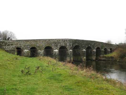
Doonmacreena Bridge is recorded as bridge in Mayo. Nine-arch hump back road bridge over river, extant 1838. Part ivy-covered walls centred on triangular cutwaters to piers to upriver (east) elevation having pyramidal capping with lichen-covered "saddleback" coping to parapets.
Why it was built
The saved account records: Nine-arch hump back road bridge over river, extant 1838.
People and work
The saved account records: Part ivy-covered walls centred on triangular cutwaters to piers to upriver (east) elevation having pyramidal capping with lichen-covered "saddleback" coping to parapets.
How it changed
The saved account records: Series of nine round or segmental arches between cast-iron "Pattress" tie plates with repointed voussoirs.
What survives
The saved account records: Sited spanning Dalgan River with unkempt grass banks to river.
Why it mattered
Doonmacreena Bridge matters for the exact reasons given in its official assessment, rather than merely because it is an old structure. The source records: A narrow bridge representing an important component of the eighteenth-century civil engineering of south County Mayo: meanwhile, a discreet benchmark remains of additional interest for the connections with cartography and the preparation of maps by the Ordnance Survey (established 1824). This explains what the place adds to local life, the street or the surviving built history.
History checked 15 August 2026 against the named sources below.
Places near here
- Doonmacreena Bridge — KINNAKINELLYbuildingunder 0.1 miles
- Doonmacreena Bridge — Doonmacreenamonumentunder 0.1 miles
- Doonmacreena Br. — Kinnakinellymonumentunder 0.1 miles
- house — DOONMACREENAbuildingunder 0.1 miles
- Castle — unclassified in Doonmacreenacastleunder 0.1 miles
- Fish Pond — Doonmacreenamonumentunder 0.1 miles
- Earthwork in Doonmacreenamonumentunder 0.1 miles
- Enclosure in Doonmacreenamonument0.2 miles
- Indicated — Doonmacreenamonument0.3 miles
- aviary/dovecote/pigeon house — CREEVARDbuilding0.3 miles
- Pigeon Ho. — Creevardmonument0.3 miles
- Enclosure in Creevardmonument0.4 miles
Add the human story, a picture, a first-hand message or a missing place.
Earn 5 points after the picture is checked and accepted.
Add a pictureAdd its storyTalk or ask a questionAdd a new placeThis official record and map point do not grant access. Most recorded buildings are privately owned; view them only from public ground unless the owner allows entry.
Conversation about this place
Questions and messages sit beneath the source record. They are checked before appearing.
No questions or messages yet.
Ask a question or join the conversation