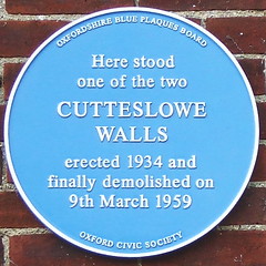
What is recorded here
This blue commemorative plaque records: Here stood one of the two Cutteslowe Walls, erected 1934 and finally demolished on 9th March 1959 Recorded plaque organisation: Oxfordshire Blue Plaques Board, Oxford Civic Society.
Cutteslowe Walls were part of a pair of walls built in 1934 to mark the boundary of Oxford's Cutteslowe Park; they were significant local landmarks until their demolition in 1959.
A plaque record does not grant entry to a building or private land. View it from a public place unless permission is clearly given.
Places near here
 Church of St Michael and All AngelsListed building · 677 yd
 Grave of J. R. R. TolkienHeritage attraction · 1050 yd
 Church of St PeterListed building · 1204 yd
 Benchmarked boundary stone on west bank of River CherwellMonument or public art · 1579 yd
 Iris MurdochMemorial · 1678 yd
 Boundary Stone in Port MeadowMonument or public art · 1.2 mi
 Sir James MurrayMemorial · 1.2 mi
 The BathersPicnic place · 1.3 mi
 Aristide Maillol's statue of FloreMonument or public art · 1.4 mi
 Sparsey BridgeViewpoint · 1.4 mi
 Flooded footpath by Sparsey BridgeHeritage place · 1.4 mi
 Trout IslandWood · 1.5 mi
Other information
Photo: Owen Massey McKnight · CC BY-SA 2.0