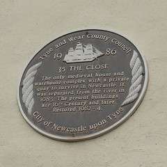
What is recorded here
This black commemorative plaque records: 35 The Close. The only medieval house and warehouse complex with a private quay to survive in Newcastle. It was separated from the river in 1985. The present buildings are 16th Century and later. Restored 1982-4. Recorded plaque organisation: Tyne and Wear County Council, City of Newcastle upon Tyne.
This site represents one of Newcastle's few surviving medieval commercial structures, highlighting the city’s historical importance as a trading hub and preserving evidence of its ancient architectural heritage.
A plaque record does not grant entry to a building or private land. View it from a public place unless permission is clearly given.
Places near here
 Milepost NewcastleMonument or public art · 39 yd
 28 and 30, CloseListed building · 75 yd
.jpg?width=1280) Former Fish MarketListed building · 97 yd
Former Fish MarketListed building · 97 yd The Tyne BridgesMemorial · 136 yd
 Old Tyne Bridge (land arches)Scheduled monument · 147 yd
.jpg?width=1280) Castle Keep & Castle GarthVisitor information · 177 yd
Castle Keep & Castle GarthVisitor information · 177 yd Hanover StreetVisitor information · 203 yd
 Rise and Fall, Sculpture in Gateshead Riverside ParkPublic sculpture · 223 yd
 The GuildhallMemorial · 230 yd
 Wreck of wooden boat in River Tyne mudShipwreck · 290 yd
 Statue of Queen VictoriaMonument or public art · 328 yd
 High Level BridgeListed building · 100 yd
Other information
Photo: Simon Harriyott · CC BY 2.0