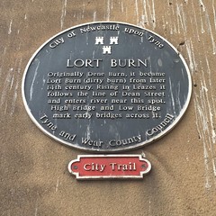
What is recorded here
This black commemorative plaque records: Lort Burn. Originally Dene Burn, it became Lort Burn (dirty burn) from later 14th century. Rising in Leazes it follows the line of Dean Street and enters river near this spot. High Bridge and Low Bridge mark early bridges across it. Recorded plaque organisation: City of Newcastle upon Tyne, Tyne and Wear County Council.
Lort Burn, originally named Dene Burn, is a watercourse in Newcastle upon Tyne whose name changed to Lort Burn (meaning dirty burn) from the later 14th century; it has been marked by significant landmarks such as High Bridge and Low Bridge, reflecting its historical importance in local geography and urban development.
A plaque record does not grant entry to a building or private land. View it from a public place unless permission is clearly given.
Places near here
 The GuildhallMemorial · 33 yd
 The Guildhall and Merchants' CourtListed building · 35 yd
 13, SandhillListed building · 53 yd
 Old Tyne Bridge (land arches)Scheduled monument · 91 yd
 The Tyne BridgesMemorial · 98 yd
 All Saints ChurchVisitor information · 179 yd
 All Saints Church and Akenside HillVisitor information · 193 yd
 Milepost NewcastleMonument or public art · 196 yd
 St Mary's Heritage CentreHeritage attraction · 270 yd
 Rise and Fall, Sculpture in Gateshead Riverside ParkPublic sculpture · 291 yd
 Wreck of wooden boat in River Tyne mudShipwreck · 493 yd
 Tyne Bridge (also known as New Tyne Bridge)Listed building · 58 yd
Other information
Photo: Simon Harriyott · CC BY 2.0