What is recorded here
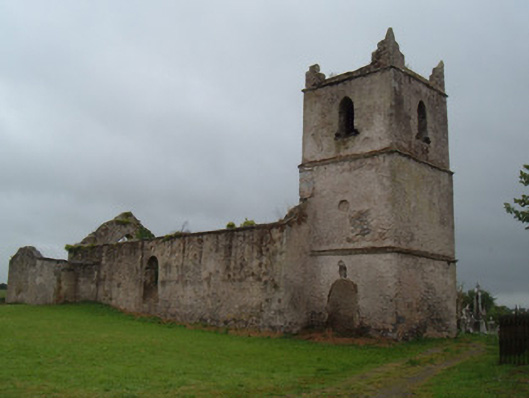
In NW quadrant of graveyard (CO027-041001-), immediately N of Glanworth village. Ruin of the former C of I parish church of Glanworth, consisting of a nave with tower at the W end. It was built in the early 18th century on the site of the earlier parish church (CO027-041003-) which was in ruins in 1615, and still in 1694 (Brady 1863. vol. 2, 214-6). Smith (1750, vol. 1, 344) describes the church as 'lately rebuilt'- this probably dates the construction rather that a refurbishment. The communion plate presented by the bishop to the 'Church of Glanore' in 1723 could mark the date of consecration. The tower was added c. 1799 (Grove White 1905-25, vol. 3, 136-7).
The walls are rendered over random-rubble limestone, with ashlar quoins. The rectangular nave (22m EW; 9m NS) has 3 pointed blocked windows in the S wall and 2 in the N wall. There is a vestry at the E end of the N wall with a burial vault inside. The E window was a tall pointed light, which was removed to the Dominican friary church (CO027-040----) where, according to local information, it originally came from. The pointed W doorway has a cut limestone surround; it is now blocked. The tower is 3-storey, with each floor diminishing in size with height and marked by a string course; there is a blocked door in the S wall. The tower is topped with raised pinnacle-like corners.
The above description is derived from the published 'Archaeological Inventory of County Cork. Volume 4: North Cork' (Dublin: Stationery Office, 2000). In certain instances the entries have been revised and updated in the light of recent research.
Date of upload/revision: 14 January 2009
Photographs attached
CO027-041002-_01: View of the church from NW.
CO027-041002-_02: E gable of the church, from E.
CO027-041002-_03: Tower and S wall, from S.
CO027-041002-_04: Interior of the church, from E.
The monument record does not grant public access. Check the route and ask the landowner before entering private land.
- What survives
- Recorded monument
Places near here
 Glanworth Churchchurch/chapel · 1 yd
 Graveyard in BoherashGraveyard · 20 yd
 friary (in ruins)Church · 69 yd
 Hut site in BoherashHut site · 100 yd
 St Dominick's WellSpring · 173 yd
 Glanworth Castle (in Ruins)Castle, Anglo-Norman masonry castle · 247 yd
 Glanworth CastleCastle · 251 yd
 Grave Yd (Site of)Graveyard · 630 yd
 Flat cemetery in Ballyenahan NorthFlat cemetery · 3.9 mi
 Blackwater (Avondhu) WayWalking route · 3.9 mi
 Johnson's WoodForest · 4.2 mi
 Priest's WoodForest · 4.4 mi