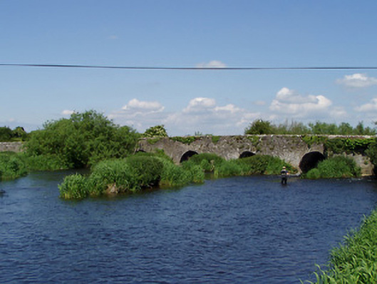
What is recorded here
Nine-arch road bridge over River Suir, built c.1600, possibly partly rebuilt c. 1780, with rectangular plan pedestrian refuge to south. Coursed rubble limestone walls with roughly dressed limestone V-cutwaters to north elevation. Slightly-pointed round or parabolic arches to north elevation and segmental arches to south elevation, all with roughly dressed limestone keystones and voussoirs.
This sweeping bridge forms an important local landmark. Its simple form belies the necessary technical and engineering skills needed to build such a bridge. It is notable for its solid construction and the textural contrast between the roughly dressed limestone voussoirs juxtaposed against the rubble limestone masonry. Its early origins are evident in the wicker centering of the soffits of the arches.
This does not grant access. Most recorded buildings are privately owned; view them only from public ground unless the owner allows entry.
Places near here
 Camus Br.Bridge · 9 yd
 Flour millWater mill, unclassified · 62 yd
 Camus Castle (in ruins)Castle, unclassified · 148 yd
 Site of ChurchChurch · 699 yd
 Enclosure in Ballynahinch (ballygriffin Par.)Enclosure · 1.0 mi
 Ballynahinch Castle (in ruins)Castle, tower house · 1.6 mi
 Hore AbbeyHeritage attraction · 2.1 mi
 Rock of CashelHeritage attraction · 2.2 mi
 The Rock Of CashelVisitor information · 2.3 mi
 Black mulberryBlack mulberry · 2.4 mi
 Dundrum Woods (Marl Bog)Forest · 5.5 mi
 Soloheadbeg Ambushambush · 9.7 mi
Other information
Photo: National Inventory of Architectural Heritage · Website use allowed for educational or private purposes with source credit