What is recorded here
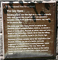
This brushed metal commemorative plaque records: The National Trust for Scotland. The Caiy Stone. Standing at over nine foot high on a summit, originally with wide views, this broad slab of red sandstone includes a line of six, probably prehistoric, cup marks on its reverse face. The stone may have been erected as early as the Neolithic period, possibly before 3000 BC, to denote a ritual or burial place. Records of cairns, cists and urns found in the immediate vicinity show that the hilltop continued to be used for burial in the Bronze Age. Discovery of these remains led to the supposition that Caiyside Hill was the site of a battle, variously suggested to have involved invading Romans, Danes (Vikings); or Cromwellians. The Caiy Stone, also known as the Kel Stane, the Cat Stane or the Camus Stane, was thought to have been a battle memorial stone.
The Caiy Stone, a prehistoric monument possibly dating back to before 3000 BC, is significant for its cup marks and potential use as a ritual or burial marker; its location on Caiyside Hill has led to associations with various historical battles.
A plaque record does not grant entry to a building or private land. View it from a public place unless permission is clearly given.
Places near here
 Caiy StaneCup Marked Stone (neolithic) - (bronze Age), Graffiti (19th Century), Standing Stone (neolithic) - (bronze Age), Standing Stone (prehistoric) · 19 yd
 The Caiy StoneVisitor information · 19 yd
 Edinburgh, FairmileheadCist(s) (period Unassigned), Inhumation(s) (period Unassigned), Cinerary Urn(s) (period Unassigned) · 394 yd
 Edinburgh, Camus Avenue, Comiston HouseHotel (20th Century), House (19th Century) · 471 yd
 Edinburgh, Oxgangs Road, Hunter's TrystInn (post Medieval), Public House (20th Century) · 520 yd
 Cockit Hat PlantationWood · 783 yd
 The BuckstaneHeritage attraction · 1003 yd
 Edinburgh, Winton DriveNo Class (event) (21st Century) · 1136 yd
 Wood, GalachlawForest or wood · 1177 yd
 Edinburgh, Oxgangs, Firrhill DriveNo Class (event) (period Unassigned) · 1350 yd
 Buckstone SnabMountain / peak · 1429 yd
 Redford WoodVisitor information · 1678 yd
Other information
Photo: Anne Burgess on Geograph · CC BY-SA 2.0