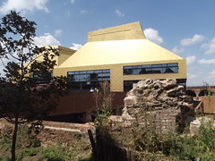
What is recorded here
This brushed metal commemorative plaque records: The site of the City Wall This bridge leads from the top of the city wall to The Hive. Worcester city wall was built by the citizens in the late 12th century. It had several towers and three gatehouses. Over the centuries the wall decayed, was rebuilt, and was used as a stone quarry. Below here the city wall is entirely rebuilt in brick. Recorded plaque organisation: Worcestershire County Council, University of Worcester.
The Worcester city wall, constructed by citizens in the late 12th century, featured multiple towers and three gatehouses. Over time, it decayed, was rebuilt, and was used as a stone quarry; below this point, the wall is entirely rebuilt in brick.
A plaque record does not grant entry to a building or private land. View it from a public place unless permission is clearly given.
Places near here
 Northwall HouseListed building · 56 yd
 The Hive and an elephant sculpture, WorcesterPublic sculpture · 91 yd
 The Paul Pry Public House and Attached Rear WallListed building · 131 yd
,_Jaguar_House,_Castle_Street,_Worcester_-_geograph.org.uk_-_4055749.jpg?width=1280) Castle StreetVisitor information · 278 yd
Castle StreetVisitor information · 278 yd Frederick Dancox VCMemorial · 302 yd
 Worcester city centreScheduled monument · 308 yd
 South Quay FountainsHeritage attraction · 354 yd
 Sir Charles HastingsMemorial · 359 yd
 Siege of Worcestersiege · 380 yd
 Cripplegate ParkVisitor information · 382 yd
 St Alban's ChurchScheduled monument · 456 yd
 Diglis IslandIslet · 1.0 mi
Other information
Photo: Elliott Brown · CC BY-SA 2.0