Overview
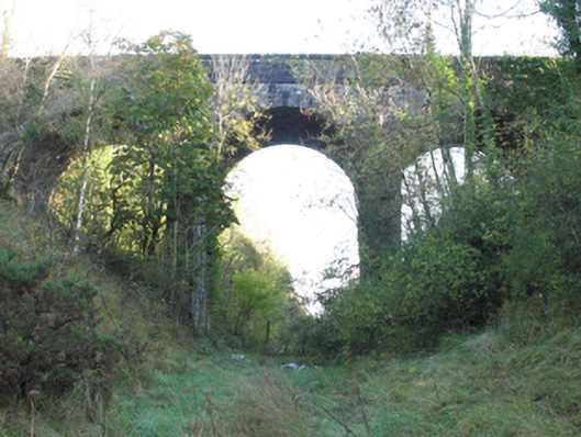
bridge — CALTRAGH, CARROWMARLEY is recorded as bridge in Mayo. Three-arch road bridge over railway line, begun 1891 Tuck pointed snecked rock faced limestone walls centred on ivy-covered piers with rock faced cut-limestone stringcourses supporting parapets having lichen-covered rock faced cut-limestone coping.
Why it was built
The saved account records: Three-arch road bridge over railway line, begun 1891
People and work
The saved account records: Tuck pointed snecked rock faced limestone walls centred on ivy-covered piers with rock faced cut-limestone stringcourses supporting parapets having lichen-covered rock faced cut-limestone coping.
How it changed
The saved account records: Series of three round arches with drag edged rock faced limestone ashlar voussoirs centred on drag edged rock faced cut-limestone keystones.
What survives
The saved account records: Sited spanning uprooted railway line with unkempt embankments to railway line.
Why it mattered
bridge — CALTRAGH, CARROWMARLEY matters for the exact reasons given in its official assessment, rather than merely because it is an old structure. The source records: A viaduct-like bridge identified as an important component of the late nineteenth-century civil engineering heritage of the rural environs of Claremorris on account of the connections with the development of the Claremorris and Ballinrobe Branch of the Midland Great Western Railway (MGWR) line (opened 1892) by the Ballinrobe and Claremorris Light Railway Company (formed 1884; absorbed 1924) with the architectural value of the composition confirmed not only by the rock faced surface finish demonstrating good quality workmanship, but also by the lofty "sweep" of the arches making a dramatic visual statement at a… This explains what the place adds to local life, the street or the surviving built history.
History checked 15 August 2026 against the named sources below.
Add the human story, a picture, a first-hand message or a missing place.
Earn 5 points after the picture is checked and accepted.
Add a pictureAdd its storyTalk or ask a questionAdd a new placeThis official record and map point do not grant access. Most recorded buildings are privately owned; view them only from public ground unless the owner allows entry.
Conversation about this place
Questions and messages sit beneath the source record. They are checked before appearing.
No questions or messages yet.
Ask a question or join the conversation