What is recorded here
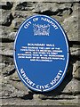
This blue commemorative plaque records: Boundary Wall. This marked the limit of the town from its medieval origins until 1835, when its first extension took in the workhouse (now part of St Woolos Hospital) and Pillgwenlly Recorded plaque organisation: Newport Civic Society, Newport Council.
This boundary wall marked the extent of Newport from medieval times until 1835, delineating the town's growth and development over centuries.
A plaque record does not grant entry to a building or private land. View it from a public place unless permission is clearly given.
Places near here
 Eglwys Gadeiriol St Gwynllyw, Casnewydd; St Woolos Cathedral, Newport; Eglwys Gadeiriol Casnewydd; St Woollos Church; St Gundleus's Church; St Woolos Church; Newport CathedralChurch; Cathedral · 8 yd
 St Woolos CathedralVisitor information · 90 yd
 Queen Victoria MemorialMemorial · 121 yd
 1839 Chartist Route MarkerMemorial · 127 yd
 Victoria Place, No.10BTerraced House · 216 yd
 Transformer, Park Square, NewportTransformer Box · 270 yd
 Park Square, NewportStatue · 277 yd
 Royal Gwent HospitalVisitor information · 425 yd
 Merchant Navy MemorialHeritage attraction · 486 yd
 Newport Museum and Art GalleryMuseum · 495 yd
_(geograph_5154362).jpg?width=1280) Newport Medieval ShipWreck · 735 yd
Newport Medieval ShipWreck · 735 yd Newport Castle, MonmouthshireCastle · 981 yd
Other information
Photo: Robin Drayton on Geograph · CC BY-SA 2.0