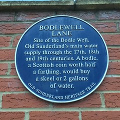
What is recorded here
This blue commemorative plaque records: Bodlewell Lane. Site of the Bodle Well, Old Sunderland 's main water supply through the 17th, 18th and 19th centuries. A bodle, a Scottish coin worth half a farthing, would buy a skeel or 2 gallons of water. Recorded plaque organisation: Old Sunderland Heritage Trail.
Bodle Well served as Old Sunderland's primary water source for centuries, supplying residents from the 17th through the 19th centuries. The well's name derives from the bodle, a Scottish coin used to purchase water by volume, reflecting its economic and social importance in local history.
A plaque record does not grant entry to a building or private land. View it from a public place unless permission is clearly given.
Places near here
 Bolt sculpture, St Peter's RiversidePublic sculpture · 285 yd
 Church of Holy TrinityListed building · 313 yd
 Crane Sculpture by River Wear mirror imagePublic sculpture · 407 yd
 Lampholder in Centre of Trafalgar SquareListed building · 408 yd
 Bede's Way monumentMonument or public art · 510 yd
 Victoria Hall disasterstampede · 769 ydVictoria Hall Disaster MemorialMemorial · 816 yd
 Sunderland War MemorialMemorial · 904 yd
 Milepost, SunderlandMonument or public art · 1324 yd
 Roker BeachVisitor information · 1.2 mi
 Hendon BeachBeach / strand · 1.5 mi
 The Lighthouse, Roker Cliff ParkLighthouse · 1.6 mi
Other information
Photo: Simon Harriyott · CC BY 2.0