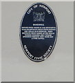
What is recorded here
This blue commemorative plaque records: Baneswell. Before piped water in 1848, Newport's 19,000 inhabitants drew from springs and wells as in medieval times. Districts were named after wells, though cholera and typhoid epidemics indicate they were not a pure supply. Recorded plaque organisation: Newport Civic Society.
Baneswell was one of several water sources in Newport before the introduction of piped water in 1848; its historical importance lies in reflecting the town's reliance on wells for water supply, which, despite being a traditional medieval practice, contributed to outbreaks of cholera and typhoid.
A plaque record does not grant entry to a building or private land. View it from a public place unless permission is clearly given.
Places near here
 St Luke's Church, Bridge Street and Railway StreetChapel · 95 yd
 Victoria Assembly Rooms; Lyceum Theatre, Bridge Street, NewportAssembly Rooms · 106 yd
 Railway Street Chapel, Railway Street, NewportChapel · 138 yd
 Corporation Baths, Stow Hill, NewportSwimming Pool · 156 yd
 The Old Post OfficeMemorial · 355 yd
 Newport Bus Travel CentreVisitor information · 360 yd
 Queen Victoria MemorialMemorial · 416 yd
 Newport Museum and Art GalleryMuseum · 426 yd
_(geograph_5154362).jpg?width=1280) Newport Medieval ShipWreck · 441 yd
Newport Medieval ShipWreck · 441 yd St Woolos CathedralVisitor information · 514 yd
 Newport Castle, MonmouthshireCastle · 534 yd
 Merchant Navy MemorialHeritage attraction · 793 yd
Other information
Photo: Jaggery on Geograph · CC BY-SA 2.0